JTICI Issue Vol.8. No.4, pp.48 to 66, 2025
Cartographies of Control and Care: Colonial Archives, Postcolonial Land Alienation, and the Reclamation of Indigenous Spatial Epistemologies
Abstract
Attappady is a home for the indigenous communities like Irula, Muduga and Kurumba. These communities maintained a strong connection with their land. They have their own system of ecological management, hunting-gathering, and shifting cultivation based on the indigenous knowledge systems. They derived their spatial comprehension of land from relational governance, spiritual relationships, and collective ownership, rather than from fixed notions of individual property. Attappady experienced significant socio-ecological changes in the post-1950s over the past century. As a result of the extensive migration of non-tribal populations, the proportion of Indigenous communities in Attappady decreased significantly from 99% in 1959 to approximately 43% by 2022. This article is an attempt to look at how the maps and surveys have played an important role in the historical dispossession in the colonial and post-colonial periods and the disruption of the life of Adivasis in Attappady through indigenous epistemologies, decolonial geography, and oral history of Attappady. Altogether, these indigenous strategies offer amazing chances to reconsider and refine colonial cartographic frameworks.
Context of the Study
Colonial and post-colonial cartography and assessments in Attappady have caused significant epistemic and material harm to its Adivasi populations. These interventions supplanted Indigenous spatial patterns with state-defined boundaries, converting forests into extractive resource zones, community lands into private property, and constrained traditional mobility and sense of belonging. By portraying Indigenous lands as “vacant” or “underdeveloped,” these cartographic narratives legitimised the seizure of land under the guise of development. Consequently, 71% of tribal respondents indicate that economic hardships are prompting land transfers, which in turn erode ancestral agriculture and diminish dietary diversity. This includes vital crops such as ragi, chama, thomara, cholam, and pulses, ultimately affecting food security (Down to Earth, 2013; Herald Open Access, 2023). Concerning health statistics emerged: 40.9% of children aged 0–59 months are stunted, 27.4% are wasted, and 48.3% are underweight, while 43.3% of adolescent tribal girls experience stunting (PubMed, 2023; PMC, 2023). From 2012 to 2021, 121 infant fatalities were officially documented; however, campaigners contend that the actual number exceeds 150, citing the disintegration of Indigenous health institutions and care networks (Times of India, 2022). Environmental deterioration due to deforestation, loss of biodiversity, and fragmentation of sacred areas has further undermined ecological knowledge and community resilience (Down to Earth, 2013). At the same time, the traditional government that depended on customary councils was replaced by panchayat systems, leading to a reduction in political autonomy (Down to Earth, 2013; IJCMS, 2020). The accumulated disturbances can be viewed as a form of cartographic disruption, affecting Indigenous understandings of space and their intrinsic relationships with the land. This work enriches the discussion surrounding decolonial spatial narratives by examining Attappady as a site of both dispossession and resistance. It views mapping as a significant political and ethical pursuit, while highlighting the Indigenous geographies that embody continuity, connection, and a sense of belonging.
Conceptual framework of the Study
This study is based on a conceptual framework that combines spatial epistemologies, cartographic violence, territoriality, and decolonial theory, referencing the contributions of Indigenous scholars and critical theorists. Spatial epistemologies, as defined by Taiaiake Alfred (2009), underscore the relational, experiential, and culturally situated essence of space, contesting colonial representations that disintegrate and distort Indigenous perspectives. The elimination of Indigenous place names and the disregard for traditional land tenure systems have facilitated state-driven legal and developmental dominance, negating Indigenous existence and sovereignty. Vine Deloria Jr. (1969) and Linda Tuhiwai Smith (1999) critically analyse cartographic violence and the coloniality of mapping, demonstrating how Western cartography and research methodologies have historically enabled dispossession through imperial ideologies. In contrast, Indigenous relational ontologies and territoriality, as articulated by Barnhardt and Kawagley (2005), regard land as sacred and sentient, interacting through reciprocity, ritual, and ecological stewardship rather than ownership. These spatial actions challenge existing maps and assert land as a relational ontology linked to sovereignty. Rob Nixon (2011) defines “slow violence” as colonial spatial regimes degrading Indigenous political institutions and ecological systems slowly. Walter Mignolo (2009) and Linda Tuhiwai Smith (1999) further developed decolonial theory and epistemic disobedience to challenge Western epistemological hegemony and affirm Indigenous knowledge systems as dynamic, sovereign, and essential to spatial and political rearticulation. Foregrounding Indigenous resilience, relational worldviews, and the pursuit of epistemic autonomy, this critical article reconceptualises mapping as a deeply political act, rather than solely a technical operation.
Methodological Framework of the Study
This research employs a decolonial, participatory, and Indigenous-centered methodological framework to examine the cartographic violence inflicted upon the spatial epistemologies of the Irula, Muduga, and Kurumba communities in Attappady, Kerala. According to Smith (2012), Indigenous knowledge is rooted in spirituality, oral tradition, cosmology, and seasonal cycles. Indigenous communities are repositioned as co-producers of knowledge with the study. Narrative walks, engaged observation, and memory mapping are employed to underscore indigenous spatial perspectives (Crampton, 2010; Harley, 1989). The construction of dialogical historiography through communal memory and engaged observation by Bodhi (2018) challenges colonial narratives. State-produced maps and development strategies are contrasted with Indigenous depictions to illustrate land dispossession, jurisdictional fragmentation, and ecological marginalisation (Harley, 1989; Crampton, 2010). Oral history interviews, community workshops, and engaged observation foster concepts of ethical partnership. Sensory ethnography (Pink, 2009) demonstrates that Indigenous spatial epistemologies are multimodal, involving embodied memory through olfactory, auditory, and tactile experiences, hence illustrating the inadequacy of colonial-modern cartographies in representing real Indigenous spatiality.
Part I. Cartographies of Care and Control – Colonial Interventions
This part of the paper will provide you with detailed information on the archival reports and the way colonial interventions could dominate the Attappady area through their care and control.
(a). Proceedings of the Board of Revenue, dated January 31, 1860.
In 1860, Malabar collector P. Grant recorded the settlement in the Attappady valley, indicating the existence of several tribes, including Burgars, Malars, Kurumbars, Erralers (Irula), and potentially five or six Kaundar households. The interests of the Malabar inhabitants were chiefly concentrated on the Attappady Valley, which were formerly a thriving centre for timber trade. The Nayars, Teeyars, and Mappilas engaged in the illicit trade of timber. The valley contained no government land aside from the reserve forest, with private estates held by three notable Janmis: Mannarghat Mooppil Nair, Eralapad Raja of the Zamorin dynasty, and Kizhakkepat Tharawad. The whole valley falls within the jurisdiction of the revenue village of Attappady. Mannarghat Nayar possesses a considerable expanse of land within the Attappady Valley.
(b). Proceedings of the Board of Revenue, proceeding number 477, Misc., dated February 1, 1901 and G. O No 907, September 1, 1903.
The revenue department of Madras requested the Malabar collector to propose a reorganisation of village establishment in Malabar district and the implementation of the Village Cess Act on February 1, 1901. The modification of village establishment in the Walluvanad Taluk of the Malabar district was implemented on September 1, 1903. Attappady Amsom was formally founded on September 1, 1903. The proposal divided the current 63 Amsom of the Walluvanad Taluk into 118, including the Attappady Valley, which spans 128,000 acres and is characterized by ongoing riots and disputes. The administration of the village will be done by the Adhikari, who belongs to the prominent and affluent Tarawad(family) of the area. The order No. 197, Revenue, dated 22 March 1899, proposes the formation of a village police force in Malabar; however, the Malabar collector rejected the initiative, citing the extensive populations and scattered dwellings, which rendered it unfeasible for talaiyaris to conduct nighttime patrols or oversee unfamiliar persons. The Amsam Adhikari, with the assistance of Kolkarans, duly reports criminal activities and potential suspects to the nearest police station.
(c). Board of Revenue (land revenue) Forest No. 74, 13th March 1911
Mr. C.E.C. Fisher’s 1911 inspection report delineates the circumstances of tribal communities inhabiting 20 hamlets within the government forest territory of Attappady Valley. These tribes engaged in shifting (Punam) cultivation and were deemed essential for forest management activities, including fire control, boundary maintenance, and the collecting of forest goods. The introduction of a land usage fee led to the desertion of the majority of villages, except for Muthikulam, where the surviving residents sought evacuation. The document proposes the provision of land to tribes at no expense, subject to rigorous conditions: restricting cultivation to specified zones, forbidding land sales, requiring cooperation with headmen, and compelling tribes to assist forest officials and function as forest police. Criminal prosecution will be the result of the violations. The report emphasise that these circumstances have continuously exploited the tribal communities for the benefit of the government from 1911. They were offered some incentives, such as incentives for fire protection and free grazing for the cattles. The main purpose of this is to use the tribes as labour force to meet the administrative and forest management requirements. The study highlights the need to recognize and address the ongoing issue of the exploiting the local indigenous communities in Attappady.
(d) Report of the Tahasildar, Valluvanad, dated, 8th June, 1914
In 1914, K.P. Sankunni Menon, the Tahsildar of Walluvanadu, conducted a survey of the Attappady valley and identified approximately 7,000 indigenous individuals—Irulas, Mudugas, Kurumbas, Badugas, and Goundas—residing in 105 dispersed hamlets. These people engaged in terrain-specific agriculture, growing diverse crops on arid soils and inclines, whereas European settlers introduced plantation crops like coffee and tea. The study meticulously examines how colonial and landlord activities, especially the introduction of European plantation crops, undermined indigenous authority and led to the displacement of tribal territories. Notably, the Siruvani estate (George Harley), Varadimalai (U.H. Oakes), and Varagumpadi (Langayya Goundan) were established by European colonisers as plantations for coffee, tea, and cardamom. This transformation of land use disrupted native governance structures. The Mooppan (village headman) was in charge of local governance and agricultural administration, while two janmis primarily managed land tenure. The janmis got their customary rents from village chiefs instead of directly from farmers. The report talks about the harsh climate, the limited benefits of the monsoon, and the unique social and agricultural structure of the people who live in the valley.
This study examines the effects of prolonged leases, and the displacement of tribal areas through migration. The people’s tears illustrate their sentiment of having “the bread taken from their mouths.” According to the report, in order to preserve their rights as indigenous people and prevent them from having to relocate again, Irula families should be granted five-acre plots of land. At the same time, it advocates for soil and forest preservation. The conventional ways of making a living faced challenges due to the Janmis’ opposition to tribal land farming and their desire to lease to external parties. This report highlights the vital importance of safeguarding Attappady’s resources and ensuring equitable land distribution.
(e) R.O.C No.127/Supr. of 1918 dated 18th October 1918 of A.M.C. Littlewood
According to A.M.C. Littlewood’s 1918 report, which tracked the intricate legal disputes over land ownership between the government and local elites, the Janmis’ authority over the Attappady valley was marked by significant internal tensions. Court decisions ultimately divided the valley’s lands among three main parties: Eralapad Raja, Moopil Nair of Mannarghat, and Gopala Menon, despite government attempts in the late nineteenth century to claim control of the upper Bhavani watershed. Post-1950, despite the Malabar collector’s reports on Attappady’s development, progress was impeded by malaria and inadequate infrastructure, constraining colonisation and resulting in the valley being predominantly in private ownership, with the exception of reserve forests. By 1951, ideas for government-sponsored colonisation were deemed imprudent, with suggestions, instead focused on enhancing health and communication, which would organically draw settlers from the plains. Report said that this kind of development could put the indigenous hill tribes at risk, and they really want to make sure that any progress should keep their well-being in mind. The WHO’s push for anti-malarial efforts led to some migrant folks moving around, especially after the Travancore Christians settled in. This caused a quicker displacement of less trained and marginalised indigenous communities, as the report points out.
(f) Report by the Commissioner of Land Revenue and Development, Madras Presidency (1955)
The 1955 paper by Sri W.R.S Sathiananthan presents an exhaustive examination of the Attappady valley, an area of roughly 280 square miles distinguished by its rugged topography, extensive woodlands, arable land, and substantial population. At that time, the valley was primarily owned by three principal janmis, with only conserved woods designated as government property. The population comprised more over 11,000 tribal individuals residing in 120 hamlets, together with approximately 1,570 non-tribal migrants drawn by timber resources. The report emphasises the conventional social hierarchy of the tribes, overseen by the Mooppan, and identifies the critical problem of soil erosion, primarily linked to the changing agricultural methods of the Irula tribe. The study recommends that tribes transition to permanent agriculture through the step-by-step distribution of land, utilising either Punam farming or leasing marshlands, to prevent land loss to external parties and promote sustainable habitation. The study underscores the urgent need for a comprehensive research and relocation strategy for Attappady, highlighting shortcomings in existing forest conservation laws and the region’s insufficient infrastructure. It necessitates enhanced road connectivity, superior health and communication facilities, and the establishment of cooperative organisations to safeguard tribal interests against predatory moneylenders. The report recommends partitioning the expansive Attappady valley into multiple smaller revenue villages, each with specified headquarters, and advocates for the appointment of a dedicated official to oversee multi-departmental development coordination. These efforts aim to improve administrative efficiency, promote the valley’s transformation, and secure the welfare and long-term stability of its indigenous inhabitants according to the report.
This section, utilising colonial archival sources from 1860 to 1955, outlines the demographic and spatial changes in Attappady, marked by a steady increase in both tribal and non-tribal populations. A critical juncture occurs when the colonial administration’s failure to effectively govern Janmi-held territories necessitates a strategic shift towards a dual approach of control and care. Subsequent reports, particularly the 1955 document, provide evidence of this recalibration, which facilitated the expansion of infrastructure in the region. Nevertheless, the 1st November 1956 formation of Kerala marked the beginning of a new phase of internal colonisation, which was characterised by the continued neglect of protective legislation for tribal land rights and state-sponsored migration. This trajectory is the subject of the subsequent section.
Part II. Internal Colonization and Postcolonial Land Alienation
Since the 1930s, Attappady has experienced a consistent stream of migrants from several regions of Kerala and Tamil Nadu, predominantly consisting of small landowners and tenants from the Gowda caste and Christian groups in southern Kerala. The migrants obtained land from local janmis at minimal costs, utilising the lenient regulatory framework and the commercialisation of land during the late colonial era.
When the Kerala Land Reforms Act came into effect in the 1960s and 70s, it was heralded as a radical egalitarian intervention that sought to dismantle the feudal/janmi system and redistribute land to the tiller. But in Attappady, it produced starkly uneven outcomes. Migrant settlers, many of whom had encroached on tribal lands in the 1950s and 1960s, were allowed to formalise their ownership through pattayam (title deed) allocations. Their literacy, understanding of the legal system, and the support of local revenue officials—who were often amenable to settler narratives of hardship and advancement—collectively facilitated these transfers. On the other hand, the Adivasis were sidelined from the documentation processes due to their collective land ownership, illiteracy and general scepticism of the State institutions that had long criminalized their substance practices.
The development initiatives in Attappady, which characterised the region as underdeveloped, underutilised, and requiring integration, intensified the erosion of Adivasi sovereignty over their land. The establishment of the Attappady Block post-1962, along with various state-sponsored initiatives such as watershed development plans, road construction, and tribal welfare settlements, generally enforced uniform geographical classifications that further divided Adivasi regions (Kalathil 2004). The activities were meticulously planned, analysed, and executed without prior consultation with Indigenous communities, disrupting the social and ecological frameworks that had sustained Indigenous ways of life for decades. As Bhukya (2021) argues, the logic of internal colonisation occurs by criminalising Indigenous sovereignty and normalising colonial privilege, frequently under the guise of welfare and development.
The trajectory of land alienation in Attappady illustrates a troubling pattern of state-sanctioned dispossession, commencing with the colonial deforestation for infrastructure initiatives such as the Silent Valley hydroelectric dam in the 1970s and persisting through the postcolonial era under the pretext of legal reforms and developmentalism. The tribespeople were relocated from Silent Valley to unstable and non-arable slopes as a consequence of the extensive deforestation of forestland surrounding Agali prior to the project’s completion. The shift was exacerbated by the tribespeople’s inability to produce legal documentation for the land they had traditionally occupied and cultivated.
The Kerala Scheduled Tribes (Restriction of Transfer of Land and Restoration of Alienated Land) Act, 1975 (KST Act) was established to combat significant land alienation, prohibiting the transfer of tribal land after 1960 and mandating the restoration of alienated lands. However, the Act was mostly ineffective due to delayed implementation, bureaucratic apathy and political opposition. The Irulas, Mudugas and Kurumbas, lost more than 10,000 acres of land by 1997, got further marginalized through procedural exclusions, because most of them did not have recognized titles with them. Subsequent years observed intentional governmental endeavours to undermine the KST Act. In response to increasing settler dissent, the government proposed Amendment Bills in 1996 and 1999 aimed at legitimising tribal land transfers up to January 1986, so compromising the original intent of reparation. The revisions, presented as measures to prevent communal conflict and protect settler livelihoods, faced significant criticism from tribal leaders and human rights organisations. The state provided unproductive lands and minimal compensation to tribal communities while proposing resettlement packages for settlers funded by the public, thus entrenching the dispossession it had pledged to rectify.
The discontent with political parties led to the rise of Adivasi-led land conflicts in the 1990s, as the judiciary intermittently mandated the government to implement restoration decrees. However, the administration demonstrated hesitation, referencing opposition from settlers and various bureaucratic challenges. The fundamental entitlements of indigenous populations—pertaining to territory, autonomy, cultural conservation, and the right to dissent—were systematically eroded.
In 1976, the State Planning Board observed, and in 1982, the Menon Commission emphasised, that land alienation undermined the economic and social underpinnings of the tribes, amounting to ethnocide. The government prioritized settler colonialism over tribal justice, violating both constitutional guarantees and court orders, which is clearly evidenced by the failure of the state to restore that Adivasi land and violation of indigenous rights by its continuous attempts to amend the protective legislation even now.
The appropriation of indigenous land in Attappady illustrates a profound cartographic violence, wherein state-sanctioned maps and surveys have been utilised to validate corporate intrusions. The Windmill Company’s acquisition of more than 374 acres—exceeding the requirements for energy production—significantly coincides with regions designated as gold-rich by Deccan Gold Mining Limited (2006–2008). Notably, the corporation began land occupancy shortly after the conclusion of DGML’s exploration, hinting that energy infrastructure may be used as a pretext for future mining operations. This deliberate reallocation of tribal land for extractive purposes demonstrates how spatial mechanisms enable capitalist accumulation. Furthermore, tourism initiatives and resort developments have expedited the degradation of indigenous ecological knowledge and territorial connections. Notwithstanding unequivocal evidence of land alienation, the state persists in complicity, permitting settler expansion and corporate domination to be etched onto the land—transforming maps into tools of exclusion and ecological devastation.
Land alienation was articulated through a unique Indigenous spatial epistemology in dialogues with the Irula community of Vattalakki Hamlet. Approximately 3,000 land alienation lawsuits have been initiated in Attappady and are currently pending resolution. The community perceives Community Forest Resource (CFR) mapping as a method to reclaim ancestral lands and challenge the structural deficiencies of the state. As the saying goes, “a thorn must be removed with a thorn.” The CFR mapping initiative, which is spearheaded by local youth in collaboration with the Adivasi Action Council, the Adivasi Mooppan’s Council, and the Thaikkula Sangham, employs modern geospatial technologies that are rooted in Indigenous spatial worldviews.
The next section of the article will deal with the Irula concept of land, identity and autonomy.
Part III: Indigenous spatial epistemologies and restorative mapping practices
In contrast to Cartesian or cadastral mapping systems, which rely on fixed coordinates and ownership demarcations, Indigenous people delineate their territories through oral tradition, ritual practices, and environmental indicators, such as rivers, hills, stones, trees, animal pathways, and ancestral burial sites. This dynamic map is conveyed through language, song, and everyday activities, and these attributes are of social, spiritual, and ecological significance. The historical significance and functional characteristics of localities in Attappady are encapsulated by names such as Koppaikkadavu (burial grove), Kothukad (hoe-cultivated forest) and Kalkandiyooru (grazing field). Mooppans (elders), community events, and seasonal rituals pass down knowledge of these places from one generation to the next. This means that mapping is not a one-time thing, but a way to recall and reaffirm belonging. These traditions not only keep cultural memory alive, but they also fight against state-led cartography systems that often break up and sell off Indigenous territories. So, indigenous cartography isn’t just about finding things; it’s also about remembering, reclaiming, and connecting with them.
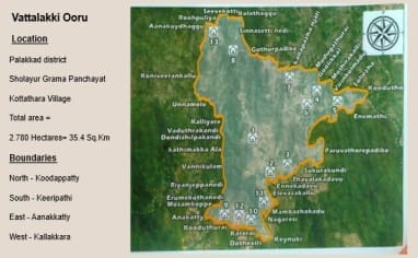
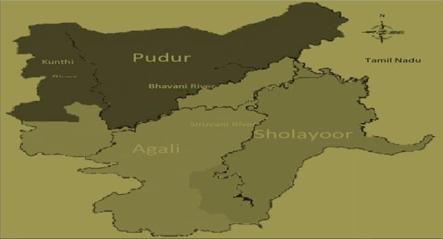
“Our land is not divided by lines, but by the flow of rivers. The Bhavani, Siruvani, and Kunthi rivers don’t just water our fields—they shape our lives. Bhavani guards Agali. Kunthi belongs to Pudur’s people. Siruvani river is the lifeblood of Sholayur. When we crossed a river, we knew we were entering another ooru’s space. There were no border stones, only water and respect. The rivers knew which clan belonged to which place. We don’t know the logic of the maps today. But we still carry the rivers in our stories”, said Choriya Mooppan.
“We didn’t say forest; we said what it gave us. One hill was known as Thenkaadu, the honey forest, where bees made their home in high crevices. Another ridge we called Moongilkunnu, the bamboo hill, where we cut poles for our houses. These names are not decoration—they are instruction. They tell us when to harvest, where to go, what to protect. The forest was named after its gift. But now they call it ‘Reserve Area’ or ‘Survey Plot 102’. Tell me—how do you find honey in a number?”, asks Nancha Mooppan.
“Kallappazha Njali is where the earth begins to murmur with sweetness. It is the habitat of the kallapazham, the wild fruit that adheres to the steep inclines and matures quietly. According to elders, this fruit transcends mere sustenance; the initial Mooppan did not cultivate any, yet the trees emerged, as though the ground desired our permanence. Underneath the roots of these trees, a spring emerges, originating the Kallakkara Pallam river, which meanders through the fissures and thickets, transporting the essence of the fruit to far regions. Children follow its flow to learn its turns, and the name Kallakkara itself lives in their mouths, unbroken through generations. Here, the fruit, the river, and the people are part of the same story—a story told not on paper, but by walking, tasting, and listening to the land”, said Murukan pointing to the Kalla Trees.
“Choriyannoor, is an ooru was founded by Choriya Mooppan, a honey-collector known for his deep knowledge of rock bees and flowering cycles. He led the Kurumba people through the cliffs, and his name became the place. Choriyanur is not just a hamlet—it is a way of moving gently through the forest, listening to the bees and the wind. Dasannoor is an ooru founded by Dasan Mooppan likewise. Bhoothi Vazhi means ‘the way to Bhoothi Mooppan’s house’. It wasn’t just a direction—it was a relationship. It told us whose house it was, who welcomed us, who fed us during the festival. Sambarkkode is an area where the Irulas of Sambar clan inhabit”, said Vellankiri..
“We do not forget our dead. When a person leaves the body, we wrap them in leaves and place them beneath the earth, beneath a tree that will remember. That grove is called Koppaikkadavu—koppai means the dead body, kad means forest or grove. No one builds there. No one disturbs it. It is a sacred edge between the living and those who still walk with us in spirit. The grove becomes the boundary—not to keep others out, but to keep memory in”, said Murukan.
Regarding Koodappatti, Babu says, “Kooda” means shelter, and “petty” means basket. The place was where families from different oorus shared grain during hard seasons. When hunger came, the people gathered here under one shelter and shared from the basket. Koodapetty is remembered as the place where hunger was defeated through sharing—not through walls, but through the weaving of lives”.
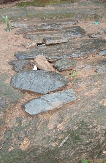
Figure No.2 Photos of (Annakkuzhi) Grain Granary with Granite Slabs at Koodappatty.
There is a place known as Veettikkud. “Veettu” means house, and “kund” means pond or depression. This was the site where the first house of the hamlet was built near a shallow water source. The spring never dried, even in the summer. It became the place where people drew water with gourds and told stories around the fire. The house and the water made the land sacred. There are houses on both sides of the stream”, said Palanichami.
“Vatta” means round, “lakki” refers to a sacred elevation. This was a ritual space where people danced in a circle during seed-sowing festivals and nights after dinner. The dance is known as “gilliyattam”. Everyone will participate in it irrespective of their age and gender. The hill was seen as a belly of the land, where fertility rituals were conducted. Vattalakki still holds songs in its soil. Even if the fields have changed, the songs rise when someone remembers,” said Murukan.
“Our way of life has always been about foraging and shifting cultivation,” said Makkala Moopan, his voice calm but firm. “We believe the land must be used in cycles, not taken all at once. Every part of this land—we remember it, we know it. Each space has a use, a memory. We even know which areas the wild animals visit, and we’ve always lived in co-existence with them.” He paused, then added with concern, “But now, even the smell of the land is changing. These modern soaps and detergents, they bring unfamiliar scents. That’s why the animals get confused—and that’s why attacks are happening more often.”
“You see, nothing really changed despite all the tribal protection laws,” said one of the youths from Attappady. “Land is still being taken, and malnutrition and infant deaths keep rising. That’s why we started making CFR maps—using GIS tools, yes, but mostly our own memories. This is just a draft. More detailed ones are coming. We’ll include everything—rivers, hills, all the places we know by heart. Our children are also having their own child rights over their ancestral lands”.
Discussion
The case of Attappady provides a compelling example of how colonial and postcolonial state interventions have reshaped Indigenous landscapes through a combination of legal, political, and cartographic forms of violence. The genesis of Attappady’s transformation can be traced back to the late 19th and early 20th centuries, when the region was first piqued by state interest through infrastructure projects like the Silent Valley hydroelectric project, estate formations, and colonial forest settlements.
Early British records intermittently recognised the existence and customary rights of Adivasi communities, including the Irulas, Mudugas, and Kurumbas; nonetheless, these acknowledgements were predominantly superficial and aligned with the imperial objectives of territorial demarcation and resource exploitation. The enactment of the Madras Forest Act (1882) and subsequent land surveys catalysed a transition from communal, kinship-oriented landholding to transferable property systems, thereby institutionalising eviction as a legal reality.
The developments following independence significantly sped up this process. The integration of Attappady into Kerala’s state framework and the land reforms of the 1960s and 70s significantly shaped the narrative of agrarian justice, yet this story largely overlooked the tribal communities. Migrants, mainly Christians and Gowndas from Malabar and Tamil Nadu, successfully obtained land titles via pattayam regularisations. In contrast, the Adivasis, without formal documentation, found themselves pushed to more marginal lands.
The expansion of settlers, bolstered by electoral strength and missionary connections, forged a new political economy where tribal lands were seized through bureaucratic control, coercive transfers, and deceptive dealings. Even with the introduction of the Kerala Scheduled Tribes (Restriction on Transfer of Land and Restoration of Alienated Lands) Act in 1975, its impact has been significantly diminished due to slow implementation, political interference, and poorly designed amendments. The state’s involvement in corporate land acquisition—highlighted by the Windmill Company and the alleged mining interests driving its purchases—underscores how the rhetoric of development conceals the ongoing undermining of Indigenous land rights.
Unlike the rigid confines of cadastral maps, Indigenous spatial epistemology in Attappady is centred on kinship, ecology, and functionality. Toponyms like Kothukad (land cultivated with a hoe), Kalkandi (pasture for cattle), or Choriyanur (settlement of Choriyan Mooppan) illustrate a profound and dynamic connection with the soil. These names are transmitted throughout generations not via formal recording, but through narrative, songs, seasonal rituals, and the moral authority of Mooppans. Rivers function as both physical boundaries and biological and cultural demarcations; hills and stones act as mnemonic anchors. This type of mapping is neither static nor symbolic; it is performative and experiential.
The current displacement of Adivasi populations is not solely a legal matter but a significant epistemic disruption. As their toponyms are supplanted, sacred sites enclosed, and ancient pathways constructed over, the fundamental syntax through which they engage with the land is deconstructed. The ongoing process encompasses more than merely abolishing land ownership; it fundamentally challenges the very essence of land—its conceptual framework, language, and the inherent connections people share with it. To foster a truly impactful dialogue on land restoration in Attappady, it is essential to move past simple formal restitution. We must embrace restorative cartographies that honour Indigenous perspectives on mapping and belonging.
Conclusion
The situation in Attappady vividly highlights the persistent gap between Indigenous land rights and the spatial-legal frameworks set by the colonial and postcolonial state, evidenced by widespread evictions and deliberate changes in legal and cartographic representations. Despite the ongoing relevance of the Kerala Scheduled Tribes (Restriction on Transfer of Land and Restoration of Alienated Lands) Act, 1975, Adivasi communities continue to encounter significant violations of their land rights. This is largely attributed to fraudulent land records and misleading registrations, as evidenced by the Kerala Vigilance Department’s discovery of more than 1,500 fake land certificates—many of which were processed after the death of Mannarkkad Mooppil Nair. These forged documents have enabled fraudulent assertions over vast tribal lands, especially in customary Irula areas such as Kothukad, under the guise of janmam land transfers, despite official assurance from the Mooppil Nair lineage that no such transfers took place. This situation underscores the urgent need to address both the encroachment and the methodical, officially sanctioned destruction of Adivasi ancestral lands. Effectively implementing the Forest Rights Act (2006) and the Panchayats (Extension to Scheduled Areas) Act (1996) is crucial for achieving individual restitution and restoring communal ownership, traditional boundaries, and lost place names. The restoration of Adivasi land in Attappady must be framed as a matter of epistemic justice and historical accountability, recognising land as a vital cultural and spiritual continuum that is essential to Indigenous identity and community resilience.
References
- Akhup, Alex. 2013. “Revisiting Tribal Studies in India: An Epistemological Perspective.” Journal of Tribal Intellectual Collective India 1(1): 1–14.
- Alfred, Taiaiake. 2005. Wasáse: Indigenous Pathways of Action and Freedom. Peterborough: Broadview Press.
- Battiste, Marie. 2002. Indigenous Knowledge: Foundations for First Nations. Ottawa: National Working Group on Education and Research. [Accessed July 16, 2024]. https://www.researchgate.net/publication/241822370
- Bhukya, Bhangya. 2008. “The Mapping of the Adivasi Social: Colonial Anthropology and Criminalization of the Primitive.” Indian Economic and Social History Review 45(2): 197–224.
- Bhukya, Bhangya. 2021. Subjugated Nomads: The Lambadas under the Rule of the Nizam. Hyderabad: Orient BlackSwan.
- Bodhi, S.R. 2018. Perspectives from Within: Indigenous Knowledge and Dialogical Historiography. Unpublished manuscript.
- Bodhi, S.R. 2020. Epistemology of the Peripheralized: A Decolonial-Historical Approach. Methodologies in Social Research Series. New Delhi: Tribal Intellectual Collective India.
- Bose, P. 2015. “Forest Tenure Reform: Exclusion and Reassertion of Rights in Central India.” Conservation and Society 13(2): 193–204.
- Bryan, Joe. 2011. “Walking the Line: Participatory Mapping, Indigenous Rights, and Neoliberalism.” Geoforum 42(3): 541–550.
- Carter, Paul. 2009. Dark Writing: Geography, Performance, Design. Honolulu: University of Hawai‘i Press.
- Census of India. 1951–2011. District Census Handbooks: Palakkad. Government of India.
- Coulthard, Glen Sean. 2014. Red Skin, White Masks: Rejecting the Colonial Politics of Recognition. Minneapolis: University of Minnesota Press.
- Crampton, Jeremy. 2010. Mapping: A Critical Introduction to Cartography and GIS. Oxford: Wiley-Blackwell.
- Deloria Jr., Vine. 1994. God Is Red: A Native View of Religion. Golden, CO: Fulcrum Publishing.
- Down to Earth. 2013. “Criminal Neglect Takes Toll on Attappady Tribes.” [online] Available at: https://www.downtoearth.org.in/environment/criminal-neglect-takes-toll-on-attappady-tribes-41569 [Accessed 28 Apr. 2025].
- Edison, E., and Devi, R. 2019. “Tribal Land Alienation, Agricultural Changes and Food Culture Transition in Attappady.” South Asia Research 39(1): 61–77.
- Edney, Matthew H. 1997. Mapping an Empire: The Geographical Construction of British India, 1765–1843. Chicago: University of Chicago Press.
- Escobar, Arturo. 2008. Territories of Difference: Place, Movements, Life, Redes. Durham: Duke University Press.
- Farmer, Paul. 2004. Pathologies of Power: Health, Human Rights, and the New War on the Poor. Berkeley: University of California Press.
- Government of Kerala. 1975. Kerala Scheduled Tribes (Restriction on Transfer of Land and Restoration of Alienated Lands) Act. Kerala Gazette Extraordinary No. 673, November 14.
- Government of Kerala. 2010. Report on Alienation of Tribal Land in Attappady. Thiruvananthapuram: SC/ST Development Department.
- Harjo, Laura. 2019. Spiral to the Stars: Mvskoke Tools of Futurity. Tucson: University of Arizona Press.
- Harley, J.B. 1989. “Deconstructing the Map.” Cartographica 26(2): 1–20.
- Herald Open Access. 2023. “Millet Village, Attappady: Healthy Food Consumption and Livelihood.” [online] Available at: https://www.heraldopenaccess.us/openaccess/millet-village-attappady-kerala-choice-for-healthy-food-consumption-food-security-livelihood-income-and-employment [Accessed 28 Apr. 2025].
- International Journal of Current Microbiology and Applied Sciences (IJCMS). 2020. “Traditional Knowledge Systems in Attappady.” [online] Available at: https://www.ijcmas.com/9-6-2020/P.%20C.%20Sachana%20and%20Binoo%20P.%20Bonny.pdf [Accessed 28 Apr. 2025].
- Kalathil, Mariamma J. 2004. Withering Valli: Alienation, Degradation and Enslavement of Tribal Women in Attappady. Discussion Paper No. 87. Trivandrum: KRPLLD, CDS.
- Menon, N.R. Madhava. 1982. Report of the Committee on Tribal Land Alienation in Kerala. Thiruvananthapuram: State Planning Board.
- Mignolo, Walter D. 2007. The Idea of Latin America. Oxford: Wiley-Blackwell.
- Mignolo, Walter D. 2009. “Epistemic Disobedience, Independent Thought and Decolonial Freedom.” Theory, Culture & Society 26(7–8): 159–181.
- Mignolo, Walter D. 2011. The Darker Side of Western Modernity: Global Futures, Decolonial Options. Durham: Duke University Press.
- Moopil Nair Family Statement. 2006. Unpublished Representation Submitted to Government of Kerala. (Testimony of Saseendran Unni Avarkal, hereditary custodian of the Mannarkkad Moopil Nair Estate.)
- Nair, K. Ramachandran. 1999. “Kerala’s Tribal Land Issue: A Study in Policy Subversion.” The Hindu, September 14.
- Nixon, Rob. 2011. Slow Violence and the Environmentalism of the Poor. Cambridge, MA: Harvard University Press.
- Pink, Sarah. 2009. Doing Sensory Ethnography. London: SAGE.
- PMC. 2023. “Adolescent Nutrition in Tribal Areas of Kerala.” [online] Available at: https://pmc.ncbi.nlm.nih.gov/articles/PMC10537611 [Accessed 28 Apr. 2025].
- PubMed. 2023. “Malnutrition in Under-Five Tribal Children in Attappady, Kerala.” [online] Available at: https://pubmed.ncbi.nlm.nih.gov/37764778 [Accessed 28 Apr. 2025].
- ResearchGate.net. 2024. “Land Alienation Among the Tribals of Attappady Block of Palakkad District in Kerala.” [online] Available at: https://www.researchgate.net/publication/379483929_Land_Alienation_Among_the_Tribals_of_Attappady_Block_of_Palakkad_District_in_Kerala [Accessed 28 Apr. 2025].
- Scott, James C. 1998. Seeing Like a State: How Certain Schemes to Improve the Human Condition Have Failed. New Haven: Yale University Press.
- Smith, Linda Tuhiwai. 2012. Decolonizing Methodologies: Research and Indigenous Peoples. 2nd ed. London: Zed Books.
- Times of India. 2022. “Kerala Tribal Infant Deaths Continue Unabated in Attappady Region.” [online] Available at: https://timesofindia.indiatimes.com/city/kochi/kerala-tribal-infant-deaths-continue-unabated-in-attapadi-region/articleshow/89959041.cms [Accessed 28 Apr. 2025].
- VillageSquare.in. 2022. “Action Needed to Stop Tribal Land Alienation in Kerala.” [online] Available at: https://www.villagesquare.in/action-needed-to-stop-tribal-land-alienation-in-kerala [Accessed 28 Apr. 2025].
- Watts, Vanessa. 2013. “Indigenous Place-Thought and Agency Amongst Humans and Non-Humans.” Decolonization: Indigeneity, Education & Society 2(1): 20–34.
- Wilson, Shawn. 2008. Research Is Ceremony: Indigenous Research Methods. Halifax: Fernwood Publishing.
Dr.Manjusha K.A is Assistant Professor, School of Gandhian Thought and Development Studies, Mahatma Gandhi University, Kottayam
Have you like this article?
Was this article helpful?

 (+2 rating, 1 votes)