JTICI Issue Vol.8. No.5, pp.67 to 85, 2025
The Problematics of Urban Spaces and Urbanisation in Bodoland
Abstract
Urban spaces, urbanisation and urban living reflect the progress of social and economic growth, transitioning from traditional lifestyles especially of agricultural to one centered on modern living, industrial and commercial activities of society. With over 55% of the global population currently residing in urban areas which is projected to be 68% by the year 2050, these spaces present both opportunities and challenges for urban planners, policymakers, and the general public. This issue is particularly pressing as much of the urbanisation is occurring in the developing and underdeveloped regions of Africa and Asia. This paper reflects upon the towns and urbanisation in Bodoland and argues that though urbanisation in Bodoland has led to infrastructure growth such as roads, bridges, drainage systems, and improved quality of life and lifestyle, it has also resulted causing problems of congestion, crowding, pollution, flooding, waste management, and degradation of green spaces besides sense of loss of ownership of land and livelihoods among urban residents. Additionally, there exists a gap in policy and practice as no power has yet been devolved to Bodoland Government by the state concerning urban planning and development in keeping with the provision of the Bodoland Accord and the Sixth Schedule of the Constitution of India. The towns of Bodoland are small, administrative, tribal people dominated and residential in size, function and nature. The study is based in the towns of Kokrajhar, Udalguri and Kajalgaon using engaged observation approach.
Key Words: Urban Space, Urbanisation, Bodoland, Small Towns, Governance
Acknowledgement: The study has been supported by ICSSR, New Delhi (Vide, File No. ICSSR/RPD/MN/2023-24/ST/147)
I also thank the Peer Reviewers who made some very substantive comments and suggestions
Introduction
Urbanisation and urban living is a reflection of improvement, advancement, and development of various socio-economic, lifestyle and cultural aspects of societies. Urbanisation signifies a change from rural to urban life, transitioning from agricultural to industrial and commercial practices, along with the intensive use of land to fulfill the demands of people living within a limited area called town or city. Humanity has a long history of urban living, which accelerated during the industrial revolution period in the Western world and entailed movement of people from rural to urban areas, along with enhanced infrastructure, transportation systems, and communication (Bhagat, 2018). The 21st century has witnessed swift urbanisation, with over 55% of the current global population residing in the urban areas, which is projected to increase to 68% by 2050, primarily in the developing and underdeveloped countries of Africa and Asia (UN DESA, 2018). According to Roy (n.d.), the development of urban space arises from a complicated interaction of socio-cultural and economic lives, as well as the expressions of people and communities.
The history of India’s urbanisation dates back to the Indus Valley civilisation. Throughout ancient, medieval, and British colonial eras, various Indian cities were hubs for trade, commerce, art, architecture, education, religion, and culture. Following independence and the partition, the Census of India reports indicate that in 1951, there were 3,057 towns with a population of 62.44 million (17.29%) which increased to 2,699 towns with a population of 78.94 million (17.79%) in 1961; 3,126 towns with a population of 109.11 million (19.91%) in 1971; 3,949 towns with a population of 159.46 million (23.34%) in 1981; 4,615 towns with a population of 217.18 million (25.72%) in 1981; 5,161 towns with a population of 286.12 million (27.86%) in 2001; and to 7,935 towns with a population of 377.1 million (31.16%) in 2011. India anticipates that by 2030, around 40% of its population will reside in cities and towns.
Urbanisation and industrialisation in India have created numerous opportunities, including enhanced infrastructural growth, transportation, communication, education, healthcare services, and accelerated economic growth. However, they also have adverse consequences especially to the indigenous and tribal people. According Xaxa (2011) tribal people ‘constitute as large as 40 per cent of the all displaced population (due to development projects) though they comprise less than 8 per cent of the total population’ of India. Again according to Xaxa Committee (2014) and Fernandes (2021), development projects including urbanisation in India continue to displace a vast number of people especially those belonging to vulnerable and indigenous communities. Industrialisation and urbanisation in tribal and indigenous people inhabited areas have led to displacement and denial of resources belonging to local communities causing poverty, water shortages, and pollution of air, water, and land, as well as disrupting their interconnectedness with their environment, nature, and livelihoods (Xaxa, 2021). Thus, while urbanisation can be viewed as a chance for improved and better living standard, it has also threatened the very existence, life, livelihoods, domiciliary living and culture of indigenous and vulnerable communities. According to National Institute of Urban Affairs (2024) ensuring sustainable urbanisation in alignment with SDG-11 generally continues to be a significant challenge to planners, developers, managers, and urban authorities in India.
The study uses engaged observation (Bodhi, 2022) as it gives scope to the author to be ‘in the context’ and ‘the context’ and facilitates observation, engagement, reflection, making meaning and articulation based on experienced field realities. The article is based on in-depth experience of the author and narratives which can be heard, seen and felt around and are iterated by the participants during interactions, interviews, discussions and FGDs. Seven interviews with key informants and two FGDs with community members were carried out across the towns of Kokrajhar, Udalguri an Kajalgaon in the study. Also, secondary data related to the urban spaces of Bodoland were extracted from the Census of India (ORGI) reports and the websites of the Urban Development Department (UDD), Government of Bodoland. Figure 1 shows the towns of Kokrajhar, Udalguri and Kajalgaon. The lines in the maps of Kokrajhar and Udalguri show the municipality areas. The map of Kajalgaon does not show municipality area yet. The maps are sourced from Google Map.
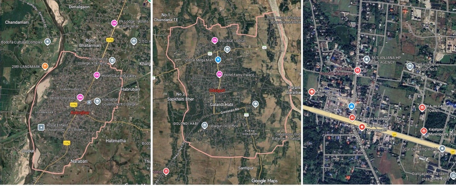
Figure 1: Maps of Kokrajhar, Udalguri & Kajalgaon Towns (Sourced from Google Map on 30 Sep. 2025. Maps not to scale)
Meaning, Definitions and Categories of Towns in India
The definitions and interpretation of a town or urban area differs across countries. In India, the concept and definition of town have evolve and developed since the colonial era of British India, with its initial definition recorded in 1901 as referenced in the Census of India (1911) which was in vogue till the Census of 1951. It was redefined in 1961, 1981, 2011 and 2018 by the ORGI (Office of the Registrar General of India) mainly for the purpose of Census count. The definitions are listed below –
The 1901 definition
- ‘Every Municipality.
- All Civil Lines not included within Municipal Limits.
- Every Cantonment.
- Every other continuous collection of houses inhibited by not less than 5000 persons, which the Provincial Superintendent may decide to treat as a town for census purpose’.
The 1961 definition
A town is an area with ‘a Municipality, a Town Committee, or a Cantonment and any other area having the following urban characteristics:
- If the population is not less than 5000
- If the density is not less than 1000 per square mile
- If the adult male population in non-agricultural livelihoods is at least 75 per cent of the total male population.’
The 1981 definition
- ‘All statutory towns, i.e., all places with a municipal corporation, municipal board, cantonment board or notified town area etc.
- All other places which satisfy the following criteria:
- A minimum population of 5,000;
- 75% of the male working population engaged in non-agricultural and allied activity; and
- A density of population of at least 400 per sq. km. (or 1,000 per sq. mile).’
The 2011 definition also cited by the ORGI (2018, Circular 2) for Census 2021
- ‘All administrative units that have been defined by statue as urban like Municipality Corporation, Municipality, cantonment Board, Notified Town Area Committee, Town Panchayat, Nagar Palika etc. are known as Statutory Town. Further, Statutory Town with population of 1,00,000 and above are categorised as cities.
- All other places which satisfied the following criteria:
- A minimum population of 5,000 persons;
- 75 per cent and above of the male main working population being engaged in non-agricultural pursuits; and;
- A density of population of at least 400 persons per sq. km. (1,000 per sq. mile).’
The ORGI also categorises towns into two types: i) Statutory Towns which are areas that have been officially designated as towns according to legal regulations, and ii) Census Towns which are villages that meet urban criteria such as i) a population of 5000, ii) 75 percent of the male population involved in non-agricultural jobs, and iii) a density of 400 individuals per square kilometer. Additionally, there exists a third category known as an urban outgrowth which is defined as a distinct unit like a village or part of a village that is adjacent to a statutory town and has urban attributes as infrastructure and services, paved roads, electricity, piped water, drainage systems, educational institutions, post offices, healthcare facilities, banks, and so on (ORGI, 2018, Circular 3).
Besides the definitions and classification of towns by the ORGI; the RBI (Reserve Bank of India) categorises Towns into six distinct Classes/Tiers based on population threshold as –
- Those with more than 1,00,000 population = Class/Tier 1 Towns
- Those with 50,000 to 99,999 population = Class/Tier II Towns
- Those with 20,000 to 49,999 population = Class/Tier III Towns
- Those with 10,000 – 19,999 population = Class/Tier IV Towns
- Those with 5000 – 9,999 population = Class/Tier V Towns, and
- Those with less than 5,000 population = Class/Tier VI Towns
Urban Spaces and Urbanisation in Bodoland
Bodoland is a tribal autonomous area which comprises of five districts. It was established under the Bodoland Accord, 2003 within the Sixth Schedule of the Constitution of India (CoI). The five districts are Baksa, Chirang, Kokrajhar, Tamulpur, and Udalguri. It is situated in the lower-western part of the state of Assam in Northeast India, bordered by the Royal Kingdom of Bhutan to the north, the Brahmaputra River to the south, and the state of West Bengal to the west. It is an outcome of a long socio-cultural, economic and political movement by the Bodo people, and three Peace Accords of 1993, 2003, and 2020 signed between the representatives of Bodo people and the Governments of Assam and India. While the first accord, signed on February 20, 1993, established the Bodoland Autonomous Council (BAC), the second accord, dated February 10, 2003, led to the creation of Bodoland Territorial Area District (BTAD) with four districts within the Sixth Schedule of the CoI and the formation of Bodoland Territorial Council (BTC) to govern itself, and the third accord, signed on January 27, 2020, rechristened BTAD as the Bodoland Territorial Region (BTR). The fifth district of Tamulpur was first established on January 20 2022, remerged with its parent district Baksa on December 30, 2022 and again re-established on August 25, 2023. On September 21, 2024, the Government of Assam incorporated 19 additional villages, primarily populated by Bodo people from the districts of Biswanath and Sonitpur of Assam, into the district of Udalguri of BTR. Currently there are 3098 villages in BTR.
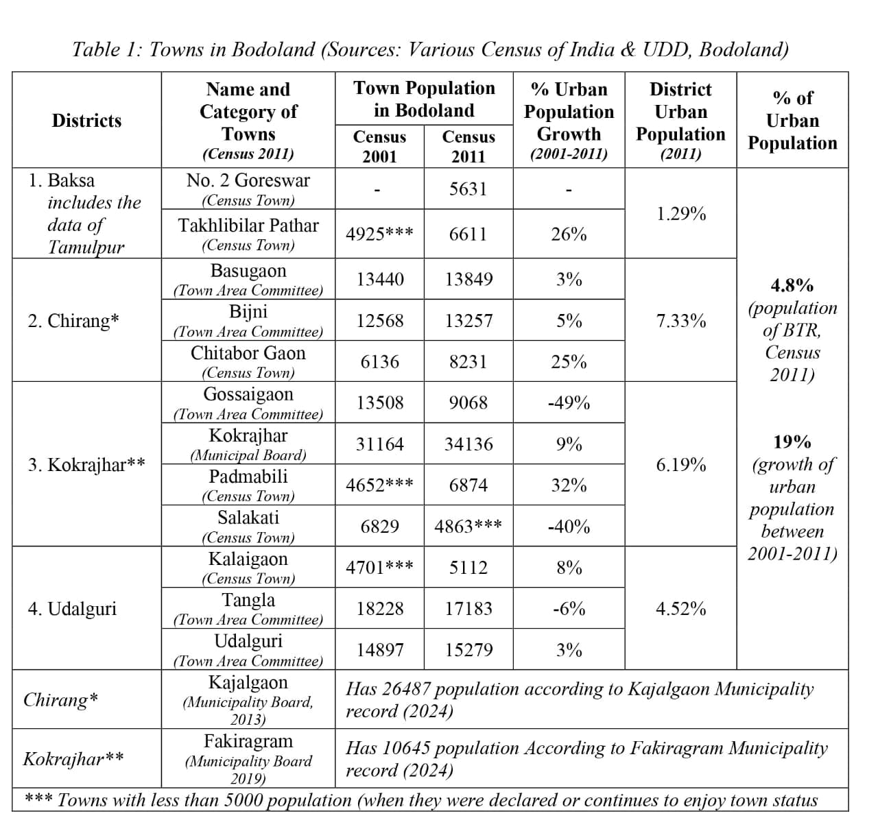
According to the 2011 Census, the population of Bodoland stood at 3.2 million, with approximately 4.8% residing in 12 towns of which six are statutory and six census towns. There is no much data on the urban population of Bodoland. But an overall decadal urban population growth between 2001 and 2011 census was 19 per cent. Of late Bodoland, which was once characterized by slow urban growth due to various reasons such as neglect, infrastructural decencies and conflicts, is now beginning to see a rapid growth and expansion of urban areas. Urbanisation in Bodoland areas seem to have spurted especially after the peace accord of 2003. And recently two more areas, namely Kajalgaon in 2013 and Fakiragram in 2019 have been declared as towns, making the figure of towns in Bodoland as 14 in number (see Table 1).
A note of Reflection
The towns of Bodoland are small, administrative, tribal people dominated and residential in size, function and nature. And as urbanisation accelerates in Bodoland, more people are beginning to live in urban areas. While the urban areas of Bodoland continue to be small, they are however expanding rapidly including beyond the municipality or town committee areas, thus overlapping with the rural areas which are under VCDCs. Such a nature of urban expansion have given rise to concerns of governance and management. Further, much of urbanisation in Bodoland is taking place at the capacity, initiative and pace of people themselves than the plan of the Urban Development Bodies. And while such model of urban expansion relieves the Urban Local Bodies (ULBs) and government of the burden of planning, cost of infrastructure development, provision and maintenance of public services like water, sanitation , drainage system, roads and transport to people; on the other hand ‘it leads to unplanned, unregulated and ungoverned nature of constructions and infrastructural development over drains, canals and low lying areas in and around urban space causing bottlenecking and congestion of vehicular traffic, water logging and flooding such that … ‘flooding has become more like an annual event than a problem in some of the towns of Bodoland’ (Interview 1). Also such model of urbanisation and outgrowths cause loss of green spaces and forested areas. What ‘were once green paddy fields and forested areas that we could see from our house have disappeared and become filled with buildings today’ (Interview 2).
One typical problem of the ULBs of small towns is a challenge of generating revenue due to limited sources especially industries and commercial activities. The ULBs of Bodoland are facing the same issue as the towns are small, administrative and residential in nature. The main source of revenue for the Municipalities and Town Committees continue to be taxes from residential houses and shops. ‘While the number of urban residents paying the municipal taxes is gradually increasing, the challenge of convincing all residents to pay the municipal taxes remains. One of the reasons for the non-payment of municipal taxes is – as the towns are tribal people dominated who are also first generation urban dwellers and traditionally not used to paying any form of taxes in the past culturally and traditionally, they do not feel the need for paying taxes to the municipalities or town committees for the houses they feel they built on their own or for property that they inherited from their ancestors’ (Interview 3). Also some of the reasons for the unwillingness of some urban residents to pay municipality taxes are feeling of dissatisfaction with services like drainage, sanitation, waste management, and drinking water supply by the ULBs. Most ‘urban dwellers of Bodoland feel that besides streets lighting’, ‘maintaining roads’ and ‘drainage system’ there is hardly any service provide by ULBs. And many also see and perceive ‘waste management’ and ‘cleaning the marketplaces’ as the only responsibilities of municipalities (FGDs 1 & 2).
The rapid nature of urbanisation in Bodoland seems to be outpacing the capacity of the ULBs to govern, provide services and amenities to the public. This has given rise to grey parallel systems of governance which operate along with the formal systems. Such systems diminish the ULB’s role and authority for governance over land, development processes and resources and encourage corruption. These grey parallel systems of governance operate openly with opacity, are unnamable yet visible to all. They are difficult to skip and maneuver around and can be found operating everywhere interfering with every aspects of life – land, housing, businesses and accessing various public services. One of such examples is what people locally call ‘dalal’ (informal brokers) without whom accessing various government services including permissions for sale/purchase of land to making certificates and licenses seems impossible. ‘When I tried to get a sale permission for my land by myself, I could not get it even after three years. I spent lots of money and time on it. But when I did the process with the help of a dalal it was done in four months. I had to pay quite a sum of money to him though’ (Interview 4). Getting work done through dalal has become an accepted practice in Bodoland (FGDs 1 & 2). This system also disconnects the common people from authorities, departments and processes perpetuating the distance and gap between government systems and the citizens. This practice also makes people lose sense of need for going through proper formal systems and ‘people continue do things like they want and as they want without approval from authorities causing inconvenience and problems to all’ (Interview 3).
In terms of authority and exercise of the powers by the ULBs of Bodoland, though the Government of Assam allocated the subject of Urban Development to the Bodoland Government in 2003 along with other subjects, the actual devolution of powers, particularly in planning, budgeting, and finance, is yet to occur. This situation complicates development planning, including urban development. Currently, the ULBs in Bodoland receive financial assistance as ‘grants’ for projects and activities that come as pre-planned and pre-designed from Government either at the Central or the State levels. This approach of urban planning and development limits the role, authority and powers of ULBs in Bodoland which is against the provisions of the Bodoland Accord under the Sixth Schedule of the CoI and the needs of local community, context and sustainability.
Besides others the burgeoning urban areas of Bodoland though promise prospects for improved living standards, they are facing an escalating and unsustainable rise of land price, and housing. ‘We bought a plot of land under the municipality area of Kajalgaon at the cost of six and half times the rate fixed by government. It is interesting to note that the price of land in the town areas of Bodoland goes up by month and not year and people continue to buy at high price with hopes that the price will still go up in future’ (Interview, 5). The towns of Bodoland are residential purpose oriented and even now ‘people buy land or a plot with intention of building a house to stay’. One of the ‘reasons for the residential oriented nature of towns of Bodoland’ … ‘is as price of land in the towns of Bodoland is very expensive local people especially those belonging to tribal communities cannot afford to buy large plots which could be used also for other purposes.’ This is ‘making the towns of Bodoland as areas with growing population but with inadequate healthcare services, quality education, affordable transportation services, safe drinking water, sanitation and other amenities’ (FGDs 1 & 2). Also a new concern which is beginning to emerge in the towns of Bodoland is ‘addiction to alcohol and drugs’, especially ‘by youth and children’ and rise of incidents of ‘violence and crimes.’ If this concerns of astronomical ‘rise of land price’, ‘inadequacy of urban services’ like health care, quality education, transportation, water supply, addiction (especially of youth) and crimes go unaddressed, the urban areas of Bodoland would become unsustainable and unsafe for its dwellers in the near future (Interviews 1, 2 & 3; FGDs 1 & 2).
A diminished sense of feeling of regret, loss of self-dignity and pride, and feeling of alienation of land have been observed among some urban people of Bodoland who once owned land/s in towns or around the town areas but have now sold them off. Though ‘selling land brought me money which has enabled building a house, but now I feel that I could have kept more land for myself to be able to at least cultivate some vegetables for our daily household consumption’ (Interview 6). Some fifteen years ago ‘these entire place was ours. We sold it away and now it is all filled with buildings. We had a big land where our family used to cultivate rice, catch fishes and crabs during monsoon season and graze our cows and bulls in the winter after the harvest. Now we have just a small plot left for the house. We used to be proud of the kind of crops we grow especially the jwsha rice (aromatic rice of Bodoland/Assam). Now we have nothing left’ (Interview 7). Losing land thus affects indigenous communities especially those who were once agricultural or pastoral. The sense of land alienation among the Bodos of urban areas of Bodoland seems to be at both at the level of common and community as well as at individual who lost land holdings and livelihoods which is similar to Sharan (2005) idea of land alienation at levels which arise 1) out of loss of common or community land, and 2) due to loss of ones holding. While a few town people who have sold off their land have made investments to sustain themselves, there are some who have not been able to, and have ended up becoming footpath vendors and daily wagers. The chance of some town people and those around urban areas of Bodoland becoming homeless, needing to live in slums or having to migrate to forested areas looking for new (virgin) land (haa.daan or haa gwdaan) and new opportunities is quite possible in the near future (FGD 1 & 2).
Problematics of Defining and Theorising the Towns in Bodoland
While in general, India defines, declares and classifies an area as a town based on various criteria including demography and nature of employment (non-agricultural) of the male population as defined by the ORGI, applying the same seem to pose challenge in the context of the towns of Bodoland. For example (see Table 1) the towns of Takhlibilar Pathar, Padmabili and Kalaigaon had less than 5000 population when they were declared towns in 2001; and also Salakati which had less than 5000 population in the census of 2011continues to enjoy the status of a town. Again while there is no clear data, on the nature of the economic engagement (agriculture v/s non-agricultural) of working male population of the towns (including the district headquarters) of Bodoland, most male population are still engaged in agricultural activities as the main means of economic activities. This again is in contrary to the ‘75 per cent and above of the male main working population being engaged in non-agricultural pursuits’ criterion for a place to be designated a town. In terms of RBI the towns of Bodoland would be categorised with the exception of one (Kokrajhar) which would be a Tire 3 Category, as either ether Tier 4 or Tier 5, and one as Tier 6 category. Thus, the towns in Bodoland could be classified as small in size. The towns in Bodoland besides being small are largely administrative (district, block or subdivisions headquarters) with a few like Salakati, Chitabor Gaon, Fakiragram and Basugaon being either industrial or important transit towns linked by roads or railways. The towns of Bodoland are evolving, growing and expanding fast which might soon enable meeting the criterion of 5000 population to be called as towns in terms of demography, but in terms of nature of employment of male population meeting 75 % threshold in the non-agricultural sector would remain for years to come by.
Urbanisation and urban expansion in general have been analysed, explained and understood from various perspectives and theories. Some of these popular theories are –
- Migration Theory of Urbanisation which states that urbanisation is a result of migration of people from rural to industrial areas. The theory comprise of various sub-theories. Some of them are 1) Buffer Theory of Migration which speaks of temporary migration of labourers based on temporary labour demand in cities. They are expected to move in and out of cities depending on the demand and need for labour; 2) Stouffer’s Law of Intervening Opportunities states that number of migrants going to a given distance is proportional to the number of opportunities at that distance and is inversely proportional to the intervening opportunities along the distance; 3) Migration Theory of Neo Classical Economists views the main reason for labour migration as influenced by wage difference between places; 4) Push and Pull Factors Theory states that favourable or unfavourable factors influence migration of people between places and cities; and 5) Urban Bias Theory emphasises that government policies favour and focus on urban areas in terms of services which cause rural people to migrate into urban areas (Nikhil (2025).
- Suburbanisation by Walker (1981) and others propounds that urban areas expand horizontally around the periphery and into suburbs due to limitation of space within the main cities. This seems typically common when cities having limitations for vertical growth and availability of easy mobility in and out or around the main city. This kind of urbanisation is often associated with urban sprawls.
- Theory of Spatial Disparity states that cities grow and develop due to advantageous geographical location, political and economic policies. This disparity and preferential treatment of some areas cause migration and urbanisation.
- Two Sector Model (Lewis, 1958) states that labourers engaged in agricultural sector migrate to support labour scarce industrial sector thus causing urbanisation.
- The Bid Rent Theory by William (1964) and others proposes that people compete to get land in urban areas with a view for profit, thus inducing urbanisation and urban growth. People purchase land in and around town areas even if the price is high as they see possibility of profitable use.
- Modernisation Theory of Urbanisation states ‘that industrialisation and economic growth, and the value orientations associated with them, … [are] the engines of social and political progress’ and view[s] that the third world societies in order to develop ‘need[s] to embrace ideas, values, techniques, and organisations commensurate with urbanisation, a complex division of labor, increased social mobility, and a rational–legal, impersonal economic and political system’ (Drake and Hilbink, 2001).
- Dependency Theory based on the writing of Singer (1950) and Prebisch (1949/1950) views urbanisation as a result of a well-developed agricultural sector and the migration of surplus agricultural and rural labourers moving into developing industries in the cities for employment.
- Urbanism as a Way of Life (Wirth, 1938) emphasises the need to ‘look beyond the mere physical structure of the city, or its economic products, or its characteristic cultural institutions’ and discover those ‘elements of urbanism which mark as a distinctive one of human group life.’
- Theory of Evolutionary Ladder of Development based on works of Thompson (1920s) and Rostow (1960) speaks of urbanision in keeping with stages of population transition and economic growth. The theory speaks of five distinct stages as 1) traditional society (pre-modern), 2) pre-take off (industrialisation/ transitional), 3) take off stage (mature industrial/ industrial), 4) stage of maturity (post-industrial) and 5) high mass consumption. According to this theory the first stage represent traditional society marked by rural living an backwardness; the second stage is characterised by development of few sectors and establishments of a few basic intuitions like banking and currencies for mobilisation of capitals; the third stage is where industries apply new technologies to increase production and economic processes replacing traditions; in the fourth stage technology is applied in every aspects of economy and investment increases along with increased standard of living and reduced poverty and in the fifth stage people live in comfort, engage in production and consumption of durable than basic goods. This is also a stage where a country or a region reaches about 80 per cent urbanisation level.
The urban areas of Bodoland pose complex challenge for explanation and theorising of their experiences, growth and expansion. While the above theories (especially suburbanisation, modernisation, migration, bid rent, evolutionary ladder and development, and spatial disparity) seem to explain partially the urbanisation in Bodoland, none of them seem to fully fit well. It calls for further study putting into focus the larger experiences, setting and context of Bodoland and its people in entity as a whole than merely focusing on pocket locations which have emerged as urban areas. A deeper analysis into the history of Bodoland with its experience of social, cultural, economic and political movement and peace accords and recognition as a Tribal Area within the Sixth Schedule of the CoI might need to be considered in theorising urbanisation in Bodoland.
A way forward
Bodoland region with its status of being a Sixth Schedule area presents a unique opportunity for planned and sustainable development including urbanisation. The current size (small), function (administrative) and nature (tribal and residential) of urban areas and urbanisation in Bodoland present opportunity for planned and sustainable urbanisation and governance. The concern of ULBs of the towns of Bodoland being financially weak could be improved by systematising and mainstreaming the revenue generation and collection processes and practices; and through promotion of more economic activities especially small and medium scale production and processing units that focus sustainability, local consumption as well as export for employment and higher revenue generation. However, care should be taken to ensure protection of the indigenous people of Bodoland from alienation of land by large scale transfer of common, community or private land for industrial and commercial activities that do not meet local people’s needs and aspirations.
Another way of increasing the revenue of the municipality would be creating education and awareness among the town dwellers (many of who are also tribal and first generation urban dwellers) on the importance of payment of municipal taxes and its uses. This could be further strengthen by the efforts of the ULBs by improving the quality of urban services like drinking water, sanitation, waste management, drainage, roads, transport and the market places. It is important to make visible quality services to the people so that they feel the need of paying ‘user fee’ for the amenities that they use.
Further, the urban outgrowths which are beginning to come around the town areas especially in towns like Kokrajhar could also be brought within the scope of the towns and ULBs for better development planning and governance. As these urban outgrowths are still comparatively small in size, it would be easy for inclusion within town areas now than later.
The services related to processing and issuing of land documents, certificates, trade licenses, and permits could be streamed lined and the interferences and involvement of the grey parallel systems and processes (what local people call dalal) be avoided and ‘ease of doing things and accessing services’ promoted. This besides reducing corruption would bring the citizens closer to the Officials, build their confidence in the authorities and also strengthen the revenue of the Government and the ULBs.
Another way of sustainable urban experience in Bodoland would be preventing large scale rural to urban migration of people by encouraging them to continue to stay in rural areas by improving and strengthen the physical connectivity (roads, bridges and public transport system) that link villages with towns for quick, easy, affordable and short distance travel to access services like health care, education and other urban amenities with ease. Also improving e-connectivity network coverage in the rural areas could be considered so that people especially youth and students are not forced to migrate or move to towns just to remain connected with the virtual world or to access e-services for education or application for jobs. These would ease crowding, congestion and unsustainable rise in price of land and housing, besides preventing further loss of green spaces, environment and ecological damages in and around urban spaces of Bodoland.
Perhaps the most important aspect of Bodoland as a Sixth Schedule area is the provision for protection of land and resources to the local indigenous communities thus preventing large scale displacements by outsiders unlike in the non-Sixth Schedule areas. It, however, calls for awareness and education among people, critical thinking and alertness among the elite and the enlightened indigenous classes, and will and action by the indigenous political class to be able to make industrialisation, urbanisation and development benefit the local indigenous people. The wish for industrialisation (including bringing in of large corporates and projects) and urbanisation in Bodoland would need careful considerations of the questions like – What is it for? Who is it for? Why is it for? or How would it affect the local communities?… and are imperative to the Bodo intelligentsia and the political class for the benefit of all.
References
- Bodhi, S.R. (2022). The Decolonial-Historical Approach in Social Research: Its Methodological Contours. Journal of Tribal Intellectual Collective India. 6(1), 1-12.
- Census of India. (1911). Census of India, Volume 1, India, Part 1- Report. Source: http://piketty.pse.ens.fr/files/ideologie/data/CensusIndia/CensusIndia1911/1911%20-%20India%20-%20Vol%20I%20(HQ).pdf, Accessed on 10 Nov. 2024.
- Census of India. (1961). Assam, district handbook of Nawgaon. Source: https://censusindia.gov.in/nada/index.php/catalog/29564/download/32745/21962_1961_NOW.pdf, Accessed on 11, Nov. 2024.
- Drake, P.W. and Hilbink, L. (2001). Latin American Studies: Politics. International Encyclopedia of the Social & Behavioral Sciences. (ed by Smelser N.J. and Baltes, P.B.). Elsevier.
- Fakiragram Municipal Board. (2024). Source: https://fakiragram.assamurban.in/about-us, Accessed on 11 Nov. 2024.
- Fernandes, W. (2021). The Poor Pay the Price: Development-Induced Displacement. Guwahati: NESRC.
- FGD 1. FGD 1 was organised with residents of Udalguri Town on 13 Jul. 2024.
- FGD 2. FGD 2 was organised with residents of Kokrajhar Town on 17 Jul. 2024.
- Interview 1. Interview with B. Iswary, a resident of Udalguri town on 29 Jun. 2024.
- Interview 2. Interview with S. Narzary, a resident of Kokrajhar town on 20 Oct. 2024.
- Interview 3. Interview with the Chairperson of the Municipal Board, Udalguri town on 16 Jul. 2024.
- Interview 4. Interview with S. Islary a resident of Kajalgaon town on 30 Oct. 2024.
- Interview 5. Interview with J. Brahma resident of Kajalgaon municipality area on 30 Oct. 2024.
- Interview 6. Interview with L. Basumatary of Kajalgan town on 21 Oct. 2024.
- Interview 7. Interview with D. Narzary of Kokrajhar town on 20 Oct 2024.
- Kajalgaon Municipality Board. (2024). Source: https://kajalgaon.assamurban.in/about-us, Accessed on 11 Dec. 2024.
- Lewis, W. A. (1954). Economic Development with Unlimited Supplies of Labour. Source: https://la.utexas.edu/users/hcleaver/368/368lewistable.pdf, Accessed on 14 Jul. 2025.
- Ministry of Urban Development, GoI. (2015). Smart Cities – Mission Statement and Guidelines. Ministry of Urban Development GoI: New Delhi.
- National Institute of Urban Affairs. (2024). India’s urban story: SDGs and urban indices across states. Source: https://niua.in/urban-statistical-profile?field_infograpgice_state_value%5B%5D=AS, Accessed on 21 Jul. 2024.
- Nikhil, N. V.S. (2025). Theories of Urbanisation. Town and Country Planning. Source: https://www.townandcountryplanninginfo.com/2020/08/theories-of-urbanization.html, Accessed on 15 Aug. 2025.
- ORGI, (2018). Census of India 2021-Circular No. 2, dated 01.09.2018. Source: https://censusindia.gov.in/nada/index.php/catalog/40511/download/44143/ORGI_circular002_2021.pdf, Accessed on 1 Feb. 2025.
- ORGI. (2018). Census of India 2021-Circular No. 3, dated, 12.11.2018. Source: https://censusindia.gov.in/nada/index.php/catalog/40512/download/44144/ORGI_circular003_2021.pdf, Accessed on 1 Feb. 2025.
- Prebisch, P. (1949, English version in 1950). The Economic Development of Latin America and Its Principal Problems. New York: UN, Economic Commission for Latin America.
- Rostow, W.W (1960). The Stages of Economic Growth: A Non-Communist Manifesto. Cambridge: Cambridge University Press.
- Roy, A. K. (nd). Defining the urban in India. Source: https://epgp.inflibnet.ac.in/epgpdata/uploads/epgp_content/S000033SO/P000293/M015142/ET/14603731386ET.pdf, Accessed on 2 Feb. 2025.
- Sharan, R. (2005). Alienation and Restoration of Tribal Land in Jharkhand: Current Issues and Possible Strategies. Economic and Political Weekly. Pp. 4443-4446.
- Singer, H. W. (1950). The Distribution of Gains between Investing and Borrowing Countries. American Economic Review. Vol. 40(2). Pp. 473-485.
- The Assam Tribune. (2024). Assam: 19 villages of Biswanath & Sonitpur districts transferred to BTR, (dated 24 Sep. 2024). Source: https://assamtribune.com/assam/assam-19-villages-of-biswanath-sonitpur-districts-transferred-to-btr-1552515, Accessed on 10 Apr. 2024.
- The Sentinel. (2022): Assam Government forms Tamulpur as new district in state, (dated 24 Jan. 2022). Source: https://gad.assam.gov.in/sites/default/files/public_utility/notification_creation_of_tamulpur_district_dtd_23-01-2022.pdf, Accessed on 15 Mar 2025).
- UN DESA. (2018). 68% of the world population projected to live in urban areas by 2050, says UN. Source: https://www.un.org/uk/desa/68-world-population-projected-live-urban-areas-2050-says-un. Accessed on 20 Mar. 2025).
- Walker, R. A (1981). A Theory of Suburbanization: Capitalism and the Construction of Urban Space in the United States. In Urbanization and Urban Planning in Capitalist Society (edt. by Dear Michael and Scott A.). London: Routledge.
- William, A. (1964). Location and Land Use: Towards a General Theory of Land Rent. Cambridge: Harvard University Press.
- Wirth, L. (1938). Urbanism as a Way of Life. The American Journal of Sociology. Vol. 44(1). Pp. 190-114.
- Xaxa Committee. (2014). Report of the High Level Committee on Socio-Economic, Health and Educational Status of Tribal Communities of India. New Delhi: MoTA, GoI.
- Xaxa, A. (2021). Sustainable urbanization in tribal or indigenous peoples’ areas of India. In Leal Filho, W., Azul, A.M., Brandli, L., Özuyar, P.G., Wall, T. (Eds.), Sustainable Cities and Communities. Encyclopedia of the UN Sustainable Development Goals. Cham: Springer. https://doi.org/10.1007/978-3-319-71061-7_126-1.
- Xaxa, V. (2011). Tribes and Social Exclusion. Occasional Paper, 2011 (2). CSSS-Unicef. Source: https://cssscal.org/pdf/unicef/OP_Virginius_Xaxa.pdf, Accessed on 14 May 2025.
Jacob Islary, is Associate Professor, Social Work, St. Xavier’s University, Kolkata. He can be reached at jislary@gmail.com
Have you like this article?
Was this article helpful?

 (+2 rating, 1 votes)